


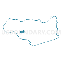
Voting District 21145, Contra Costa County, California
About
Outline

Summary
| Unique Area Identifier | 529700 |
| Name | Voting District 21145 |
| County | Contra Costa County |
| State | California |
| Area (square miles) | 5.73 |
| Land Area (square miles) | 5.73 |
| Water Area (square miles) | 0.00 |
| % of Land Area | 100.00 |
| % of Water Area | 0.00 |
| Latitude of the Internal Point | 37.90488560 |
| Longtitude of the Internal Point | -122.12827590 |
Maps


Graphs
Select a template below for downloading or customizing gragh for Voting District 21145, Contra Costa County, California


Neighbors
Neighoring Voting District (by Name) Neighboring Voting District on the Map
- Voting District 21115, Contra Costa County, CA
- Voting District 21150, Contra Costa County, CA
- Voting District 21165, Contra Costa County, CA
- Voting District 21170, Contra Costa County, CA
- Voting District 21240, Contra Costa County, CA
- Voting District 21320, Contra Costa County, CA
- Voting District 21345, Contra Costa County, CA
- Voting District 21450, Contra Costa County, CA
- Voting District 21451, Contra Costa County, CA
- Voting District 21635, Contra Costa County, CA
- Voting District 21645, Contra Costa County, CA
- Voting District 21650, Contra Costa County, CA
Top 10 Neighboring County Subdivision (by Population) Neighboring County Subdivision on the Map
Top 10 Neighboring Place (by Population) Neighboring Place on the Map
- Walnut Creek city, CA (64,173)
- Lafayette city, CA (23,893)
- Orinda city, CA (17,643)
- Reliez Valley CDP, CA (3,101)
Top 10 Neighboring Elementary School District (by Population) Neighboring Elementary School District on the Map
- Lafayette Elementary School District, CA (26,645)
- Orinda Union Elementary School District, CA (17,693)
Top 10 Neighboring Secondary School District (by Population) Neighboring Secondary School District on the Map
Top 10 Neighboring Unified School District (by Population) Neighboring Unified School District on the Map
Top 10 Neighboring State Legislative District Lower Chamber (by Population) Neighboring State Legislative District Lower Chamber on the Map
Top 10 Neighboring State Legislative District Upper Chamber (by Population) Neighboring State Legislative District Upper Chamber on the Map
Top 10 Neighboring 111th Congressional District (by Population) Neighboring 111th Congressional District on the Map
Top 10 Neighboring Census Tract (by Population) Neighboring Census Tract on the Map
- Census Tract 3400.02, Contra Costa County, CA (7,000)
- Census Tract 3540.02, Contra Costa County, CA (6,590)
- Census Tract 3470, Contra Costa County, CA (6,171)
- Census Tract 3500, Contra Costa County, CA (5,512)
- Census Tract 3410, Contra Costa County, CA (4,864)
- Census Tract 3490, Contra Costa County, CA (4,686)
- Census Tract 3480, Contra Costa County, CA (4,587)
- Census Tract 3530.02, Contra Costa County, CA (4,078)
- Census Tract 3260, Contra Costa County, CA (3,437)